General Description
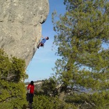
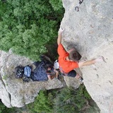
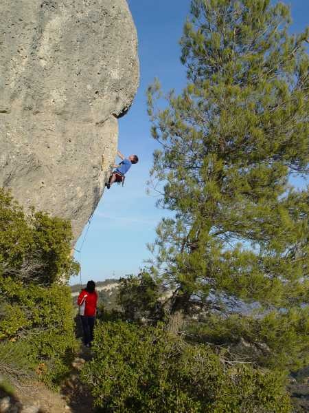
The attractive cliffs lining the hillside above the village of Vilanova de Prades are home to hundreds of interesting climbs in an extremely pleasant and open setting. The rock is a mixture of Conglomerate and Limestone-Tufa featuring pockets and edges, as well as the occasional pebble. The selection of sectors presented here offers everything from technical slabs and vertical walls, to powerful overhangs, and most have a high concentration of routes meaning that, finger-strength permitting, it is possible to complete a large number of climbs during the day with minimal time ‘wasted’ on walking.
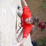
Although seldom more than 20m in length (those on sector El Curull are the exception) the routes are often very demanding. Sectors Desploms and La Llena, situated 2km west of the village, offer the best of the zone’s 8a-and-harder routes.
Approach – General:
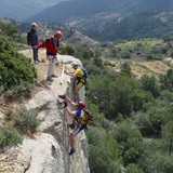
The sectors constituting the main part of the zone are situated on the long, continuous line of cliffs overlooking the village. A driveable track runs eastwards below the cliffs then back westwards above them (heading for the twin antennas visible from the village) and it is actually possible to approach the sectors from either below or above, although the latter involves a considerably longer drive and the trackside bushes can be less than kind to vehicle paintwork. Here we describe the approaches most commonly used for each sector, although in reality one may choose any approach and simply walk along the base of the crag to reach your required destination. From a roundabout at the eastern end of the village follow the track (signposted Camí a la Serra Llena and surfaced in places) uphill towards the cliffs. The former P1, a flat grassy area on the left-hand side of the track, approximately 500m from the roundabout, has now been blocked off with large stones and cannot be accessed, meaning the ‘new’ P1 is the old P2 — lay-bys on the left-hand side approximately 300m further up the track (800m from the roundabout). It is situated on a right-hand bend about 20m past a side-track (the entrance to which is blocked by a boulder) which turns sharply back leftwards. There is a white letter “P” painted on a rock on the right-hand side of the parking area. P2 (the former P3) is situated another 300m further on (1.1km from the roundabout) immediately before a sharp left-hand bend and directly below the right-hand end of the cliffs. P3 (the former P4!) is situated on top of the cliffs approximately 2.6km from the roundabout and just beyond where the track levels out. There is a yellow mark spray-painted on a pine tree here and also an Area Privada de Caça metal signpost.
Sectors
Cova de Les Bigues, La Solana, La Cogulla & Coll de L'Abella
Description: these four sectors constitute the left-hand side of the band of cliffs. Cova de Les Bigues features a mixture of short, low-grade routes together with a small cave holding a number of extremely bouldery routes and projects. The climbing on La Solana and La Cogulla is more typical for the zone — vertical, fingery and technical. Coll de L’Abella is a disjointed sector with just a small selection of short routes. Orientation: south for Cova de Les Bigues (sun for most of the day) and southeast for La Solana and La Cogulla — shade from mid-afternoon.
Approach:
From P1 walk 400m back down the Camí a la Serra Llena track to just beyond the sharp bend (it is actually the same distance from walking from the village to this point). Turn right here onto another track (surfaced in places) and follow this uphill for approximately 350m to the upper corner of a fenced-in area of land on the left. Turn right onto a narrow footpath here (there is a signpost for La Cogulla affixed to a tree on the left) and follow this up to the base of the cliff (12 min. from P1). La Solana lies immediately to the left of where the path reaches the cliff and La Cogulla to the right. Coll de l’Abella lies 70m to the right of La Cogulla. For La Cova de Les Bigues, from the left-hand side of La Solana continue walking leftwards along a sometimes vague path to reach a short rock band equipped with a mini Via Ferrata. Ascend this to reach a broad terrace below the sector (15 min). Note: in walking terms the fastest approach to La Cova de Les Bigues is from the track above the cliffs, parking in a large lay-by some 250m further on than P3 and following a well-marked footpath leading rightwards (5 min) but the extra driving time (as well as the added risk to your vehicle) needs to be taken into account.
Sector El Camping
Description:
El Camping is probably the most important area of the whole zone, featuring fifty interesting climbs on vertical or slightly overhanging walls. Orientation: predominantly south and southeast — sun until early evening.
Approach:
From P1, begin walking back along the track blocked by the large boulder, which soon narrows to trail width. After approximately 130m, and just before the trail splits, turn right onto a side-path leading uphill and leftwards (cairn where this starts and more along the way) to reach the cliffs at an area of rockfall. Here, go leftwards along the base of the wall for 70m to reach the right-hand side of the sector (8 minutes from P1).
Les Alzines, Niu de l’Àliga & Racó dels Corbs
Description:
These three sectors form the central part of the cliff and, once again, offer dozens of routes on good rock. Racó dels Corbs is probably of most interest to the 6th grade climber, while Niu de L’Àliga will mostly appeal to those operating at higher grades.
Approach:
Begin as for El Càmping: from P1, begin walking back along the track blocked by the large boulder, which soon narrows to trail width. After approximately 130m, and just before the trail splits, turn right onto a side-path leading uphill and leftwards (cairn where this starts and more along the way) to reach the cliffs at an area of rockfall. Les Alzines lies some 20m to the right of the rockfall. Continue rightwards again, past a short section of rock with no routes to reach Niu de l’Àliga. El Racó dels Corbs lies immediately right again. Note: all these sectors can also be approached from above (parking at P3) which entails a much longer drive but considerably less walking.
El Sostre & El Curull
Description:
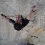
these two sectors form the highest part of the cliff and offer some of the best 6th grade climbing in the zone, as well as plenty of harder routes to choose from. Vertical walls abound, as well as a monstrous overhang featuring a recently climbed 8b for roof enthusiasts.
Approach:
From the right-hand side of P1 follow a well-marked footpath leading rightwards, more or less parallel to the main track. After 40m turn left onto another path heading directly uphill (there is a cairn on the right after 5m) and follow this steeply to the base of a section of cliff featuring an enormous roof 10m above the ground. This is El Sostre (6 min). Sector El Curull lies immediately to the right.
Pitufos, La Ruta del Cister & El Pi
Description:
these three sectors form the right-hand side of the village cliffs. Los Pitufos and El Pi feature short, low-grade routes, which makes them very popular but a little polished, while La Ruta del Cister offers some worthwhile 7th grade climbs. Orientation: predominantly south but there are some small variations on sidewalls.
Approach:
from P2 walk 10m back down the track towards the village then turn right onto a well-marked footpath climbing the steep, wooded slope to the base of sector Pitufos (5 minutes). La Ruta del Cister lies immediately to the left while the isolated buttress of El Pí is situated some 15m left again (6 minutes).
Barranc de Viern
Description: this nice sector actually lies well below the main band of cliffs and, as such, is far more protected from prevailing winds. It is an excellent location for those climbing between 4+ and 6a.
Orientation: southeast.
Approach: From P2, follow an obvious path downhill, descending a short, steep section with the aid of metal rungs in the first few metres and passing a small electricity pylon. Continue downhill, at first directly and then diagonally leftwards (multiple cairns) to reach the left-hand side of the sector (7 min).
Penya Alta:
Description:
a nice sector standing proud on the hillside to the left (west) of the main area. Access is only really practical from above, which means driving all the way up the Camì a La Serra Llena track, which may not be advisable in a none 4x4 vehicle (or hire car).
Approach:
from P3 continue driving along the CamÌ a la Serra Llena track for approximately 600m to the Antennas. About 70m further on the track splits: take the left fork (the right leads up to a nearby fire-lookout tower) and continue driving for approximately 400m to where the track ends at a col - Coll de l’Abellar (3.7km from the village). On foot, follow a wide path heading south. Unlike several other trails starting from the col this path is not signposted, but there is a large yellow letter ‘M’ painted on a rock just left of where it starts. After only 15m turn right (cairn) onto a narrow but well-marked footpath and continue along this (passing a second yellow ‘M’) for approximately 100m to where it splits (cairn). Take the left fork and 20m further on go left again (cairn) following a path running along the top of a small rock band. After approximately 80m the path descends through a notch in the cliffs to the base of the wall. Turn right (facing out) and continue along the base of the wall to reach the first routes on the extreme right-hand end of the sector (5 min from the last parking area).
La Llena
Description:
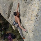
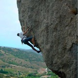
this is one of Vilanova de Prades two ‘out of town’ sectors (the other being Desploms). The best of the climbing here is in the higher grades, particularly on the magnificently overhanging buttress containing the route Megapubilla (8a) at the right-hand end of the crag. Note: on many of the climbs on the left and in the centre of the crag, the first one or two bolt-hangers have been trashed (a dispute with a local land-owner) so to do these routes you will have to take a clipstick… preferably quite a long one. Orientation: predominantly south — sun most of the day.
Approach:
Park in a lay-by (P5) on the TV-7004 approximately 2.3km west of the village and 370m west of the Km-7 marker. Walk 25m down the road (away from the village) then turn right onto a short, cemented tractor-ramp. From the top of this follow a well-marked footpath, first rightwards (passing a large boulder with an arrow scratched on it) then left, then back right, skirting the edge of almond groves. Continue on the path as it zigzags up the hillside, passing through an area of huge boulders (there are a few routes here) towards the cliffs. Where the main path finally levels out, approximately 20m from the first rock bands, a smaller trail branches rightwards (cairn) leading up to the first routes at the left-hand end of the sector (10 minutes).
Desploms
Description:
a small sector featuring some very steep and very hard power routes. Orientation: south — sun most of the day.
Approach:
approximately 2.5km west of the village a pair of dirt tracks turn left off the road. There is parking here for one or two vehicles (P6) but care must be taken not to block access to either track. On foot, cross the road and scramble up the low earth bank, then follow a vague trail leftwards to reach the remains of an old asphalted track. Cross directly over the track and continue following the vague footpath up the hillside, first leftwards and then back right, reaching the lower, left-hand end of the sector where the remains of a ruined house nestle below the cliffs (3 minutes).