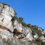
General Description:
This zone is amongst the most remote and least frequented in the region. The approaches to its various sectors, which are widely spaced throughout a large area of pine-forested hills about 1,000m above sea level, require demanding off-road driving along unsurfaced tracks (4 x 4 vehicle mandatory for two of the four sectors covered) and / or walk-ins of between 15 and 45 minutes. However, for those seeking to escape the crowds and who are not put off by a challenge, Els Cogullons is a very rewarding area in which to climb. The situations are often spectacular and the rock-quality invariably superb. The climbing is generally very steep on sharp pockets and small edges.
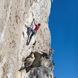
MAS DE CARLES
Description:
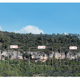
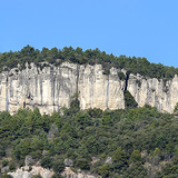
Because Mas de Carles is close to the village of Rojals and therefore requires only a short section of off-road driving it is by far the most popular of sectors in Els Cogullons. The rock is superb and, although the routes are no higher than 15m, they are full of interest and action. Tough grades! Orientation: southwest — sun after late-morning.
Approach:
from the village of Rojals drive approximately 500m along the unsurfaced track (signposted Camí de l’Arlequí / Els Cogullons) and park at the first major junction, where the Camí de l’Arquelí turns sharply left and the main Els Cogullons track continues directly ahead (P1). On foot, follow the left-hand track for 100m then turn right onto a well-marked footpath (GR-171 — red & white paint marks) and follow this across cultivated fields then down into a wooded area. Approximately 100m after entering the forest a smaller trail branches left off the main path. Follow the left-hand trail for approximately 500m, descending all the time, then turn left again onto another narrow path (cairn at the start) which is rather indistinct in places but well marked by further cairns. This path leads up to the right-hand side of the terrace running along the base of the sector (20 min).
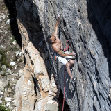
MAS D'EN LLORT
Description:
Mas d’en Llort is a long, disjointed sector offering some excellent (although quite short) routes on superb rock. Tough Grades!
Orientation: south — sun all day.
Approach:
from the village of Rojals drive approximately 1km along the unsurfaced track, signposted Camí de l’Arlequí / Els Cogullons, (passing the parking area for sector Mas de Carles after 500m). About 50m before reaching a small wooden kiosk (which sells permits for mushroom picking in the autumn and winter season) turn right and then immediately take the left-hand of two forestry tracks. After approximately 750m there is a junction with another, wider track. Park here (P2) by a metal Caça Controlada sign and also a larger wooden signpost of the Catalan Forestry Service. On foot, follow the track leftwards, uphill for approximately 250m then turn right (there is a second Caça Controlada signpost here) onto another forestry track. Continue along this for approximately 750m, ignoring a left-fork after 250m, to where the track ends at a grassy clearing. Those with 4x4 vehicles (and the necessary skills) can actually drive to this point (P3) if they wish to. Continue along a well-marked footpath heading down and left through the forest, passing below a small, undeveloped north-facing crag at one point. Just before reaching the lowest point of the valley there is a natural spring and man-made pool. Shortly after this the path joins another unsurfaced track. Turn right onto this and continue past a ruin on the left (the original Mas d’en Llort) and then a second house (the ‘new’ Mas d’en Llort). Immediately after the second house turn left onto a paved footpath and follow this for 50m to the first isolated buttresses at the left-hand end of the sector. For the main part of the sector continue along the paved path, but where this leads uphill to a metal fenced enclosure (protecting cave paintings) drop down onto a lower path and follow this rightwards. The first routes on the main sector are encountered 50m from the paved section of path (30 minutes from P2, 15 minutes from P3). This is a long, disjointed sector and the routes on its far right-hand side require a further 10 minutes of walking. Note: following periods of wet weather those without 4x4 vehicles are advised to park back on the main track, close to the wooden kiosk. This will add 10 minutes to the walk-in.
LES GRALLES
Description:
This sector consists of different pinnacles and walls separated by short walks. The rock is excellent. Orientation: generally south, so mostly sunny, but shade can always be found on the back walls of some of the pinnacles.
Approach:
4x4 vehicle required! From Rojals drive along unsurfaced tracks following directions for Els Cogullons for approximately 5km until reaching a junction just below the old Refugi. Turn right and follow a track southwards (signposted Farena /
Mas de Mateu) for 350m to park (P4) at a flat grassy area known as the Coll d’en Serra. On foot, continue along the main track for approximately 500m to where it crosses a dry streambed. About 150m further on the track splits: take the left fork and continue for a further 150m to where the track fades out. Continue along a narrow footpath (marked by three red-painted dots) forking left after 20m, to reach the first routes of the Pata Negra wall, 100m from the end of the track (15 minutes from P4).
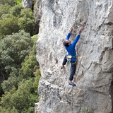
MOLA ROQUEROLA
Description:
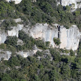
This is a superb sector! If it were in a more accessible location it would certainly be one of the most popular in the area. The best climbing is 7a and above. Orientation southeast — sunshine until mid-afternoon.
Approach:
4x4 vehicle required! From Rojals drive along unsurfaced tracks following directions for Els Cogullons for approximately 5km until reaching a junction just below the old Refugi. Turn right and follow a track southwards (signposted Farena /
Mas de Mateu) for 350m to park (P4) at a flat grassy area known as the Coll d’en Serra. Follow a well-marked footpath signposted Farena/Mas de Mateu (yellow and white paint marks). After a period of descent the path crosses a stream then turns sharply right, following the stream bank, before veering left again and continuing uphill. At the next split follow the left fork (again signposted Farena / Mas de Mateu) which soon joins a forestry track. Follow this downhill for approximately 400m to the ruins of Mas de Mateu just visible through the trees on the right. Approximately 60m further on a small path (marked by a cairn and yellow and white paint marks on a tree) heads rightwards. Follow this through the trees and at the next junction of paths (where there is a natural water spring) turn right onto a vague trail marked by a metal signpost indicating Mola Roquerola. Continue uphill, passing a limestone outcrop after 100m and occasional green paint marks on trees, until a level rocky shelf is reached at the beginning of the sector (30 min). Note: apart from the final section (after the water spring) the whole way is marked by yellow and white paint marks. Follow these and you shouldn’t get lost. An alternative approach avoiding any off-road driving is possible from the village of Farena, situated 14km west of the town of La Riba on the TV-7044 (10km after the climbing zone La Riba). The walk is both longer and considerably more strenuous than the ‘normal’ way, but such is the quality of the sector that the rewards merit the effort for those without 4x4 vehicles. Park approximately 100m after Farena on the road to Capafonts, just before a sharp left-hand bend. Walk back 30m towards the village then turn left onto a well-marked footpath signposted Mas de Mateu/ Els Cogullons and marked at intervals with yellow and white painted stripes. After 5 minutes the path splits: take the right-hand fork and continue uphill through the forest. The path soon divides again: here take the left fork (the right fork is signposted Camí Vell de Mas de Mateu). The path now steepens considerably. After approximately 30 minutes of walking the angle finally relents where the path crosses a level sandstone plateau. Shortly after this the path joins a forestry track, just by a large, circular metal water tank. Continue following the track uphill for 200m then turn left onto a footpath (another signpost here for Mas de Mateu /Cogullons) which is followed for 70m to a natural water spring. This is the junction with the ‘normal’ approach. Continue as before (45 min).
Note: A Bird-Ban is in place on this sector running from January 1st to June 30th.