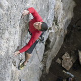
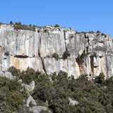
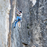
Overlooking the town of Montblanc, the cliffs of El Penitent offer excellent, technical climbing on good rock. Although harder routes are starting to appear, it is in the 5-7c range that El Penitent truly excels. With the exception of sectors Kale Brroka and Còsmic, the cliffs face predominantly south-east and this means that good climbing conditions can be found not only on sunny winter mornings, until early or mid-afternoon, but also in late-afternoons and evenings during the warmer months of the year. Kale Brroka and Còsmic, facing north and northwest respectively, offer respite from the heat if required. On the sunnier side, El Penitent La Pasquala and Roquer del Penitent are the two major sectors, supplemented by El Galliner, which offers shorter, though still nice routes. All three sectors have a roughly south-easterly orientation, so shade can be found from mid-afternoon onwards.
The only negative point is the approach track, which after rain can be really tough without a 4x4 vehicle.
General Approach: approaching Montblanc from the north-west on the N-240, midway between Km-35 and Km-36 turn off onto the TV-2421 and follow this (signposted Montblanc centre) into the town. On reaching the main road through the town centre turn left, then at the large roundabout turn right (there is a Bon Àrea restaurant on the right here). Approaching from the south on the C-14, midway between Km-34 and Km-35 turn onto the N-240a and follow this into Montblanc reaching the aforementioned large roundabout after 1.1km. Continue driving up Avinguda de Manuel Ribé through the outskirts of town to where it finishes beneath an electricity pylon (P1). The unsurfaced track starts here.
For those with suitable vehicles, follow the track, forking left at a junction after 300m and continue to a large flat area on the left (P2) with a square, brick-built water deposit, approximately 950m from P1. This first part, including a concreted section, isn’t too bad, but beyond this, the track deteriorates significantly. Note: P2 is only described as a possible ‘advance’ parking area for those without 4x4 vehicles. Approximately 1.7km after P2 (and 2.5km from the start of the track) lies P3, which is just a widening of the track directly opposite Roquer del Penitent and is only suitable for 2 or 3 well-parked vehicles. Continuing along the now level track for a further 350m leads to P4, which offers room for 5 or 6 well-parked vehicles close to a small waterworks building with a green metal door. The final, parking area, P5, lies some 200m further (3.2km from P1) directly below the ruins of a grand old house — El Mas de Pasquala. There is parking for multiple vehicles here.
Final Approaches
Kale Brroka: above P3 a well-marked trail leads first directly and then diagonally leftwards up the forested hillside, with fixed ropes to help overcome short, steeper sections. This leads to a terrace, which runs rightwards below the routes (5 min).
Sector Còsmic: from P4 walk 150m back down the track to the start of a trail marked by a cairn, a short section of fixed rope and a small wooden sign bearing the name of the sector. Follow the trail steeply uphill to a second short of fixed rope, which enables the base of the crag to be reached (5 minutes from P4).
El Penitent la Pasquala, Roquer del Penitent & El Galliner: from P5 follow a well-marked footpath signposted Zona d’Escalada El Roquer del Penitent rightwards, leading to the left-hand end of El Penitent la Pasquala (10 min). The path continues rightwards beneath Roquer del Penitent (20 minutes from P5 to the right-hand side of the cliff). An alternative starting point is P4, from where a trail leads rightwards from the small waterworks building to join the main path just before reaching El Penitent La Pasquala. El Galliner is situated above and to the right of the right-hand most routes of Roquer del Penitent and the terrace below the sector is reached by following a well-marked trail (25 min from P5). Routes on the upper tier of Roquer del Penitent are reached by following the terrace leftwards from El Galliner for 30m.
Walking Approaches: an alternative approach to Roquer del Penitent and El Penitent La Pasquala involving no off-road driving is also possible. Park by the pylon at the end of the Avinguda de Manuel Ribé (P1) then walk up the track, taking the first junction leftwards after 300m. Continue until 20m before the concreted section then turn right onto a well-marked footpath signposted Zona d’Escalada El Roquer del Penitent 2.8km. Follow this to reach a forestry track after 1.1km. Follow this rightwards for approximately 600m to a signpost for the zone marking the start of a path on the left. Beware — there are actually two paths and the signpost (despite the best efforts of local climbers to bend it!) suggests the right-hand alternative, but this is wrong. Take the left-hand path up through the forest (very steep initially) to finally reach the right-hand end of Roquer del Penitent (40 min). Note: more direct (and less strenuous!) walking approaches exist for these two sectors, but the paths are un-signposted and require intimate local knowledge.
Sectors Kale Brroka and Còsmic can be reached on foot in reasonable times from P2 (up to where the off-road track is usually in reasonable condition). From P2, walk along a forestry track heading southwards (there is a wire cable at the start of this track to keep unauthorised vehicles out) for approximately 160m, then turn right and follow a well-marked footpath steeply uphill, passing many cairns, to regain the main driving track at a wide bend. From here continue walking up the main track for approximately 500m to a huge boulder on the left. Approximately 200m beyond the boulder, a cairn marking the start of the final approach trail to Kale Brroka is reached (20-25 minutes from P2). Continue up to the sector. The start of the final approach trail to Sector Còsmic, marked by a cairn, a short section of fixed rope and a small wooden signpost, lies approximately 200m further up the track (25 minutes from P2).
L’Agulla del Cinquantenari
Description: This little sector, though not as popular as the other rock here, still offers some interesting climbs, particularly on the upper level. Orientation east — shade after late-morning.
Approach: From P5, walk back to the approach track (90m). Turn right on this and follow it to the first hairpin bend. Here a small trail cuts off to the left — follow this uphill for approximately 70m to reach the base of the cliff’s lower tier (5 minutes from P5). The upper level is gained via a short gully some 15m to the right.