Climbing has been limited
⛔️ Climbing here is not allowed. ⛔️ Climbing has been tolerated here for decades, but no longer is. Please respect this closure to protect nature and for a potential future regularisation of the crag. ... Read more
We like ⛔️Les Rochers de Juzaine ⛔️


Activities on this crag
Nearby crags


Climbing has been limited!
⛔️ Climbing here is not allowed. ⛔️
Climbing has been tolerated here for decades, but no longer is. Please respect this closure to protect nature and for a potential future regularisation of the crag. Wandering in the forest of the trails is not allowed either. Please stay on the trails.
The topos are only available for historic reference.
🇫🇷 ci-dessous
🇬🇧
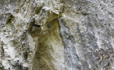
Access is free, but the area is in the Natura 2000 network, so pay extra love to fauna and flora.
The crag is located in the Province of Luxembourg, municipality of Durbuy, the valley of the Aisne, near Bomal.
🚗 Arrival by car:
From the main crossroad in Bomal, head direction "Aywaille" and turn right after about 300m towards "Izier". Pass the small church of Bomal and the « château ».
Drive another 150m and take a right on an ascending road (Allée des Faisans).
Drive about 100m more meters and park alongside the road between chalet nr 4 and nr 6, near some big rocks.
🚶♂️Approach on foot: 10min
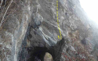
The trail starts on the right side of the road and takes you to the crag in 5min (see cragmap)
Follow the trail towards Roc à L'Aisne (5min). Immediately after passing the cliff, take a path on the right leading down. A little further, take a left towards a white bridge. Continue about 100m. The main crag is on the left, below the hill.
🇫🇷
Accès Libre, mais en Natura 2000. Donc ne pas détruire la nature.
Belgique - Wallonie - Commune de Durbuy - Bomal/Juzaine
🚗 :
Du carrefour principal de Bomal, prenez la direction d' Aywaille et tournez à droite après +/-
300 mètres en direction d'Izier. Passez devant la petite église de Bomal et le « château ».
Roulez 150 mètres et prendre a droite une rue qui monte (Allée des Faisans).
Roulez encore une centaine de mètres et se parquer le long de la route entre le chalet portant
le n° 4 et celui portant le n°6 au niveau des grosses pierres.
🚶♂️:
Le bon sentier d’accès part sur la
droite de la route. Après 5 minutes de marche, vous passez devant les rochers de Roc a 1'Aisne.
Des rochers de Roc a 1'Aisne, prendre directement le sentier de droite qui descend.
Puis un peu plus loin, à gauche vers une passerelle blanche.
Continuer à marcher une centaine de mètres. Le massif est situe sur la gauche au dessus de la butte (Secteur Principal) et au niveau du tunnel (Secteur Tunnel).
5 minutes depuis Roc a l'Aisne. Temps total 10 minutes.