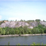
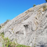
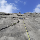
The slabs of "Corphalie" are visible from the road between Huy and Amay (left bank of river Meuse) almost in front of the nuclear plant of "Tihange" (right bank of the river). The climbing site is a succession of slabs on almost 300 meters long and "la grande dalle" is about 50 m high.
Most of the time climbing is quite easy if you follow the cracks either than climbing straight.
The characteristic of Corphalie is the "mountaineering" spirit of most of the routes with fairly spaced points (distance 5-6 m between points is quite usual). It is a good "mental" preparation for those who want to climb long and easy routes in the Alps. The leader should always avoid any fall as the fall could be long and along a slab, that means danger of hitting a ledge and of falling with the head down (the helmet is certainly a "must").
Most of the slabs are equipped with bolts, but some sectors are equipped with pegs with most of the time a fair distance between them (these routes are described as "traditional", you can add amovible protection as nuts or friends, but it will not always be easy as the cracks are most of the time fulled with earth and quite round. It is always possible to climb with the equipment in place if you are comfortable in the difficulty grade and ready to climb with some "exposition".
You need to be confident in your mind and in your feet to lead in Corphalie, as you should not "try" , but always "succeed". Some people will like it, some others not. Even if most of the routes are easy, Corphalie is for sure NOT a school-climbingsite, but more an "mountain" climbing site, certainly not recommended for beginners in the leading.
Be also careful with the length of the rope when you lower off or abseil, especially in "la grande dalle", but also in others sectors as "dalle du chemin de fer". Always tie a knot at the end of the rope and master the techniques to handle a "too short lower off".
In 1967 two young local climbers (Jean-Claude Hans and Dany Heymans) were for the first time climbing on those beautifull slabs and more precisely on "la patinoire" that became the first route here. In the following years, others local climbers as Francis Dechany, Pierre Göbbels and others from the local "caving-club" Les Gours will open other routes. Most of the routes were opened from the foot of the cliff except in the sector "Tremblotte". Around 1991, most of the routes were bolted by Richard Grebeude and Pierre Göbbels, members of UBS (Union Belge de Spéléologie). Then when the CAB took over the management of the cliff around 2000, Bernard Marnette and André Doyen were opening other easy routes with a special "mountain" character equipped with space pegs. Since that time André Doyen is maintaining the whole site ... almost alone.


Access is sensitive!
As for all belgian climbing site, you must be member of an official climbing federation to be allowed to access and climb here. For Belgians : CAB (Club Alpin Belge), KBF (Klim- en bergsport Federatie), UBS (Union Belge de Spéleo) for foreigners : NKBV (Nederlandse Klim- en Berg Vereniging), FFCAM (Fédération Française des Club Alpins de Montagne), FFME (Fédération Française de Montagne et Escalade), DAV (Deutsche Alpen Verein) ... and all federations member of UIAA. You must have your valid member card with you and show it in case of control.
Camping, bivak and fires are forbidden on the whole area.
How to reach the cliff
By train : Huy railway station is about 3 km to the west of the cliff
By bus : line 85 from
By car : GPS 75, Quai de Compiègne, 4500 HUY.
Parking : along the road or aside the car wash (leave the car wash access free !)
Access to the cliff
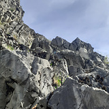
Right of and behind the car wash, you have a small tunnel under the railways then a path is leading up to the different sectors. At the first info-board, you can go right to the "Dalle du Chemin de Fer" and left to the other sectors. The next crossroads is before and under sector "Tremblotte" where you have a path going left and down to the "dalle école" and some meters further a path going right and up to the ridge above the whole cliff. Going further via a delicate passage, just above "dalle école", you reach the foot of "La patinoire" and around the corner "la Zone centrale". The path is going down on rocks (a short fixed rope) then traverse on a narrow ledge. At the end of it you can climb up some meters (fixed rope) to arrive at the foot of the routes in the left part of "Zone centrale" and also behind and above the yew, you can follow yellow marks leading to the top. Beware for this mountain goat path as the first traverse is not secured (you have a big peg at the end of the traverse to secure the follower). If you take down under the yew, you arrive under "la Grande Dalle" then always further "la Dalle des Acacias". At the left end of "Les acacias", you can scramble up (some fixed ropes) to reach the top of the cliff where you find an easy path that traverse the whole cliff and leads to the back side of "la dalle du Chemin de fer". There are 2 possibilities from the top to walk down to the foot of the cliff. The left one is the mountain goat from the left top of "La Zone Centrale" leading to the foot of "la Zone Centrale" passing at the belay of "les surplombs de l'Orvet". Beware for this path that is quite exposed. The best way is to take the path at a big cairn going down to the foot of "La Tremblote". All those path are marked with yellow markers.