The magnificent and imposing cliffs above the picturesque village of Vilanova de Meià are mostly famed for their multi-pitch routes, some of which, particularly those on the Roca dels Arcs, are regarded as being amongst the finest in Catalunya. We offer a selection of fully and partially (mostly) bolted routes on Roca dels Arcs, as well as a number of slightly shorter multi-pitch climbs on sector Amatista. The single-pitch climbing here is equally fine but somewhat rather strangely neglected, which is curious because the sectors included in our selection all boast excellent rock and offer interesting routes through a wide range of grades.
🧗♂️Parets de La Font de L’Hedra
This attractive sector, situated low in the gorge, is split into two sections: the lower part offers short, powerful routes, while the higher part of the sector is home to some spectacular tufa climbs up to 35m in length. Orientation: West.
Approach: Park in grassy lay-bys on the right-hand side of the road just before reaching a green signpost for ‘Font de L’Hedra’, about 1.3km after the village (P1). Follow the signposted path down into the streambed and cross this via a wooden footbridge then continue along a narrow, vegetated path heading rightwards for approximately 160m. Here a cairn on the left marks the start of a vague trail heading up and right to the right-hand side of the lower tier of crags. Walk back left along the base of the crag to access the routes (5 minutes from P1). For routes on the upper part of the sector, continue up and rightwards to the base of the cliff (10 minutes).
🧗♂️Paret de Les Cabres
A short sector with some powerful climbs in the 6th, 7th and 8th grades. Orientation: West. Note: because of the questionable state of the bolts and lower-offs on the first few routes (V – 6a+) these are not shown in our topos. Our coverage begins about 20m along from the start (left-had side) of the crag.
Approach: The starting point for this sector is the picnic area at La Font de La Figuera situated just before the Km-4 signpost on the L-913 heading up the valley. Opposite the font and picnic area a dirt track turns off to the right. Drive along this for 130m to park in the second of two large clearings. On foot, continue walking along the track for approximately 350m, passing two huge concrete water storage tanks on the left and then a corrugated metal fence on the right, to reach the start of the sector, which only reveals itself at the final moment (3 minutes).
🧗♂️Contrafort de Roca dels Arcs
This is the long wall situated directly below the magnificent cliffs of Roca dels Arcs. There is a mixture of bolted and traditional climbing here, but the most popular area is the central section, featuring clean rock and some excellent routes from 4+ to 6a (although many people feel these grades are on the stiff side!). Orientation: South.
Approach: P3 is a large dirt lay-by situated on the right-hand side of the road between Km-5 and Km-6, approximately 900m after passing a sharp hairpin bend. From P3 continue walking up the road for 250m to a lay-by just before a small road bridge (there is actually parking for 1 or 2 cars). From here, follow a well-marked path descending into the streambed. Cross this and then continue leftwards along the base of the wall to the foot of the sector (12 minutes from P3).
🧗♂️L’Anticúpula
This sector forms the lower right-hand side of the Roca dels Arcs formation and offers some worthwhile climbs. Orientation: East.
Approach: P4 is a series of small lay-bys on both sides of the road, close to the Km-6 marker, but for larger vehicles or just for when it’s busy, there is a more spacious parking area situated some 500m down the road back towards the village (P3). Starting 50m up the road from the Km-6 marker, follow a path down into the streambed then up the steep slope below the wall to the base of the routes (10 minutes from P4).
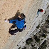
🧗♂️Amatista
This multi-pitch sport sector is part of the Parets del Pas Nou cliffs. The rock is invariably perfect and the routes a joy to climb. Orientation: Southwest.
Approach: from P4 follow a path up the rocky hillside (quite strenuous!) then scramble up slabby rocks to the slanting ramp at the base of the wall (20”).
Descent: rappel descents are possible on some routes here but the walk down is relatively easy: from the top of the wall scramble up and right then continue rightwards for about 100m to an obvious path descending through a notch. This gives access to a ramp leading back down to the base of the wall (15”).
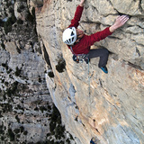
🧗♂️La Cúpula
Description: La Cúpula is definitely Vilanova’s best sport sector. The very steep central section offers some excellent 7th and 8th grade routes, while further right the angle relents and one kind find a number of very nice 6s on superb rock. Orientation: Southwest.
Approach: P4 is a series of small lay-bys on both sides of the road, close to the Km-6 marker, but for larger vehicles or just for when it’s busy, there is a more spacious parking area situated some 500m down the road back towards the village (P3). Starting 50m up the road from the Km-6 marker, follow a path down into the streambed then up the steep slope below the wall to the base of the routes (10 minutes from P4).
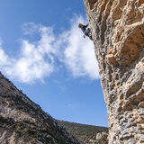
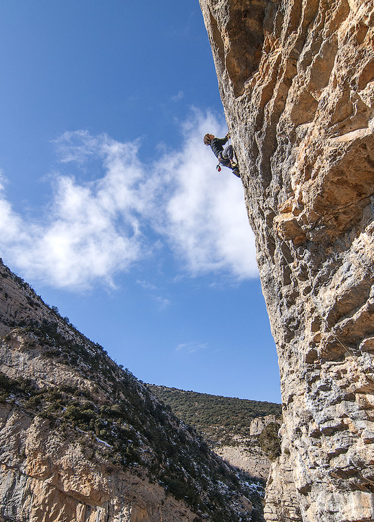
Roca dels Arcs
The unquestioned jewel of the area — a kilometre-long wall of superb limestone up to 200mts in height, and criss-crossed by nearly 80 routes; we show a selection of the better protected ones on the left-hand, central, and right-hand sections of the wall. Fine weekends, apart from in the hottest months, will usually be rather busy, with many teams attempting the more popular outings. In these situations, although the limestone is inherently sound, there is inevitably an increased risk of rock fall. The use of helmets, both on the routes, and while walking beneath the wall, seems a wise precaution. Note: unless planning a rappel descent, most teams gear-up at the car so as not to have to return to the base of the route after completion. This means you'll be carrying approach shoes (and maybe even water and belay jackets) up the climb.
Orientation: East/Southeast.
Approach: P4 is a series of small lay-bys on both sides of the road, close to the Km-6 marker, but for larger vehicles or just for when it’s busy, there is a more spacious parking area situated some 500m down the road back towards the village (P3). From P4, follow one of a network of well-marked footpaths down into the (usually dry) streambed and up the other side. The different paths soon merge and a single track leads across the wooded slope, parallel to the wall itself. The path is exposed in places and great care is needed to avoid knocking loose stones down onto the sector below (El Contrafort). At certain points offshoot paths lead up to various sections of the wall (between 15 and 30 minutes depending on the route).
Descents: From the top of Roca dels Arcs follow the crest of the wall down and right then follow a well-marked path down to the road some 200mts above the parking area. This descent is permanently shaded and can be slippery when wet or icy, conditions which may exist even when the wall itself basks in sunshine. Trainers/Approach shoes are strongly recommended (20 - 30 minutes to reach P4).
Note: Several routes are equipped for rappel, and this is noted in the route tables. However, at busy times please refrain from roping down through groups of ascending climbers: at best, you will not be popular; at worst, a serious rock-fall risk!