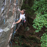
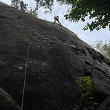
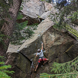
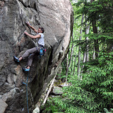
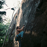
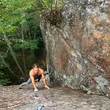
A newly found fairly large rock located on the archipelago island of Tynningö, about 4 kilometres north of the climbing crag Skevik. This is probably one of the best finds in recent years in Stockholm. The main attraction is several approximately 15 meters high onsight-friendly vertical bolted routes in the grade range 6c/7a+, which offer unusually sustained and technically demanding face climbing. Some fully bolted easier routes have also been made, hence this crag works well for those who climb routes in the lower grade range. The rock also has a few shorter bouldery and steeper routes around 7a/8a with some nice and intense climbing. A couple of good-looking traditionally protected lines are also on the menu. The rock consists of an approximately 150-meter long mostly continuous wall along which the different sectors are located. The routes are between 8 and 19 meters high, and most are above 15 meters.
The quality of the stone is somewhat varied, but mostly okay or good. Some loose material remains, especially on a couple of the easier routes. The shorter and steeper routes are usually more solid.
ENVIRONMENT:
South-Southwest. The wall is located in a wooded area and is surrounded and partially shaded by trees. It is mostly shady down at the base of the crag but higher up on the wall the sun shines here and there as the sun moves. The rock is located in a valley depression fairly well protected from wind close to a swamp/wetland. In springtime, sector Högra väggen is completely open to the sun before the leaves have come out. The rock generally dries fairly quickly, but it can drip through in some places for some days, especially at Högra väggen. It might be a good idea to wait a few days after heavy rainfall or snow melting.
FERRIES:
Free road ferries (gratis bilfärjor) depart from Norra Lagnö twice an hour and the crossing takes around 10 minutes. The ferry usually departs every hour and twenty past from Tynningö and returns no more than ten minutes later from Norra Lagnö.
SL BOAT FERRIES
New shuttle boat line with SL ticket from Slussen to Norra Lagnö.
Shuttle boat line 84 is a new line that started running on April 15. Sl tickets apply.
The ferry runs between Strömkajen – Slussen – Riset – Koviksudde – Norra Lagnö – Ålstäket. Now during the spring, there will be 6 departures in both directions on weekdays and 3 departures in both directions on weekends. Bicycles may be taken subject to space. Search for your trip at sl.se
PARKING:
Parking options on Tynningö are extremely limited. Parking has so far taken place in a couple of areas managed by Norra Tynningö Samfällighet (NTS) https://tynningo.se
These areas are probably informal parking places that appear to be used by residents or visitors to residents of the island. The locals will probably not appreciate if climbers will occupy these parking spaces. These parking areas can also be busy, especially during summer. Carpool as much as possible to minimize the number of cars. Another option (the wisest option) is to park in a large parking lot about 200 meters before the ferry stop at Norra Lagnö. Go over on the ferry and walk 2.5 km along the nice minor road to the short 200-meter path that leads into the forest and the crag.
FOOD:
Since 2022, there has been a 24-hour unmanned grocery store with a wide range of food and some other goods. Address: Tynningö Lifvs, Bygdegårdsvägen 2. You have to download an app named; Storekey, and also some type of confirmation by staff is needed the first time you shop.
Defibrillators (hjärtstartare) are available at Bygdegården (by Tynningö Lifvs)
Google Maps link: https://maps.app.goo.gl/niLR3boseLCY22YUA
Coordinates: 59.374897, 18.403473