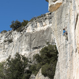
This very extensive zone is a firm favourite both with local and visiting climbers. It ticks all the right boxes: superb rock, a southerly orientation and a stunning location in the heart of the Serra de Prades mountains. The rock is rarely more than a few degrees either side of vertical, and with dozens of classic grade V’s and 6’s to choose from La Mussara is yet another of Tarragona’s low and mid-grade Meccas. The climbing here is perhaps the most varied of any of the region’s zones offering not just the usual diet of edges and pockets, but strenuous crack lines and technical bridging corners as well. All this good news comes with one caveat: many of the older classics are becoming rather polished and this, combined with some very stiff ‘old school’ grading means La Mussara is not exactly the place for massaging one’s ego!
The zone boasts a comfortable and well-run Refugi offering accommodation and meals, as well as information about the latest routes.
General Approach: the parking areas for all sectors (except P4) are situated between Km-14 and Km-16 on the T-704, approximately 20km north of Reus.
Sectors
Antenes Area (Sectors Tot Grau, Roure, Primitiu, Taronja, La Proa, Espantaocells, Follet, Del Mig, Diedres & Totxo d’en Tuc)
Description:
The Antenes sectors constitute La Mussara’s most important cliffs and stretch for more than 600m. The rock is perfect and the angle is predominantly vertical, giving very technical face, crack and groove climbing. Orientation: predominantly southeast — sun until early or mid-afternoon.
Approach:
the parking area for all these sectors (P1) is a large, grassy area approximately 600m north of the Km-15 signpost on the T-704. There is parking on both sides of the road. On foot, follow the road uphill for 50m then turn left onto a well-marked footpath heading towards the cliffs. After 200m (at the Font del Roure) the path splits: the right fork (red and white paint marks) heads up towards the TV masts, while the lower path (blue/yellow paint marks) is the one leading to the climbing. A few metres further on there is another split, this time with three alternatives: take the central path (metal plaque indicating Cami dels Cingles) which traverses horizontally left below the cliffs. From this, at various points along the way (marked by cairns) small offshoot paths lead up to the individual sectors. The first offshoot path is encountered approximately 40m after the metal Cami dels Cingles plaque and leads up to sectors Tot Grau, Roure and Primitiu (5 minutes from P1).
Sectors Taronja and La Proa are approached from a path starting approximately 300m from the metal Cami dels Cingles plaque (10 minutes from P1).
Sector Espantaocells is approached from a path starting approximately 350m from the metal Cami dels Cingles plaque (12 minutes from P1).
Sector Follet is approached from a path starting approximately 425m from the metal Cami dels Cingles plaque (15 minutes from P1).
Sectors Del Mig and Diedres and are approached from a path starting approximately 600m from the metal Cami dels Cingles plaque (18 minutes from P1).
Sector Totxo d’en Tuc is approached from a path starting approximately 700m from the metal Cami dels Cingles plaque (20 minutes from P1).
Can Pistola & Lo Mosaic
Description:
Can Pistola is a recently developed sector, while Lo Mosaic has been around for a while longer. Both sectors offer the usual La Mussara diet of vertical rock and technical climbing. Orientation (Can Pistola): southeast — sun until mid-afternoon. Orientation (Lo Mosaic): east — shade from mid-day onwards.
Approach:
from P1 drive approximately 1.25km downhill on the T-704 to a sharp right-hand bend (this is actually the fourth hairpin bend after the Km-15 marker). There are roadside parking spaces 30m above the bend, on the right (P3) as well as 50m below, on the left. Walk back to the apex of the bend, where a well-marked footpath — a section of the GR-172 (red / white paint marks) begins. Follow this downhill for approximately 100m to where it turns sharply rightwards: here turn left onto a smaller, but still well defined, trail (cairn at the junction). Continue along the smaller trail, passing more cairns, for some 400m to reach the left-hand side of Can Pistola (10 minutes from P3). Lo Mosaic lies a couple of minutes further right.
Lo Raval
Description:
A superb wall with a selection of excellent routes in the 6th and 7th grades. Orientation: south — sun for most of the day.
Approach:
from P1 continue driving along the unsurfaced track for approximately 200m to parking spaces on the left (P2). On foot, follow a well-marked path heading south, descending through the cliff-bands. At the foot of the wall continue down and left (facing out) to reach the base of the sector (15 minutes).
Lo Soterrani
Description:
Due to its perfect, grey rock and large number of routes in the lower and middle grades, Lo Soterrani is one of La Mussara’s most popular sectors. Orientation: predominantly south — sun for most of the day.
Approach:
from P2 (the parking area for sector sector Lo Raval) continue walking along the main track for a further 200m to a junction marked by a large signpost. Turn right and follow the track signposted Camí de Vilaplana for 100m then branch right again onto a well-marked footpath (a yellow triangle is painted on a cairn where the path starts). Follow the path, ignoring a right-fork after 100m, for approximately 450m, finally descending a steep rocky gully (more yellow triangles) to the foot of the cliffs. Agulla Gaudí is situated just to the right (looking out) of the base of the gully; for all other sectors turn left (15-20 minutes).
Les Campanilles
Description:
for those climbing in the 6th and low 7th grades Les Campanilles is an outstanding sector, featuring perfect rock and varied, interesting routes. The only downside is the approach walk (or rather the uphill return!). Orientation: predominantly southwest — sun after mid-day — except for routes 22-26, which face northeast.
Approach:
park beside the ruined church in the abandoned village of La
Mussara at the head of the TV-7093 (P4). On foot, follow a well-marked path uphill for 80m (signposted Vilaplana) heading towards the headland, where the remains of the old Refugi de les Airasses are situated. Just beyond the refugi there is a signpost for Vilaplana pel Camí de Les Campanilles. Follow the path downhill for approximately 450m to reach a forestry track. Turn left on this (signpost for Vilaplana per Les Tosques) and follow it for 160m to a cairn on the right. This marks the start of a small but well-marked trail, which soon reaches a dry streambed: descend this, bypassing a steep smooth slab on its right-hand side (looking out). The final few metres descend a vertical 5m wall with the assistance of some iron rungs, then turn left (facing out) and follow a path along the base of the wall before scrambling up onto a terrace below the sector (20 minutes).