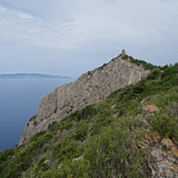
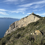
Capo D' Uomo is an iconic crag near Porto S. Stefano, south of Grosseto.
About 40 min drive from Grosseto and about 2 hours from Rome. It comprises two areas the first one closer to the approach trail is the "SPORT ROUTE" area. Moving downward towards the sea there is the multi-pitch area.
the sport routes area was initially developed by the alpine guide Eraldo Meraldi (who also developed the multi-pitch area) and more recently re-bolted and expanded with more new routes by a team of bolters from the Grosseto area.
The Torre di Capo d'Uomo is a coastal tower located in the municipality of Monte Argentario, about 350 meters above sea level, on the summit of the hill of the same name, which rises in the western part of the Argentario promontory, in a dominant position towards the sea, almost halfway between Porto Santo Stefano and Porto Ercole.
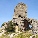
The tower was built in medieval times, most likely by the Aldobrandeschi, before a large part of their territories became part of the Republic of Siena, where the Argentario promontory was entirely incorporated. In the second half of the sixteenth century the tower became a fundamental reference for the defense system of the State of the Garrisons, being able to send light signals between the Torre di Cala Piccola and the Torre della Maddalena, which were unable to communicate visually with each other.
The tower continued to perform the original sighting functions for which it was used for centuries, only being definitively abandoned in the nineteenth century. Its position in an impervious and difficult to access place meant that there was no interest in purchasing it from private individuals, and so the ancient defensive structure underwent rapid deterioration, also favored by the place particularly exposed to action of the winds.