Description

⛔️ Climbing here is not allowed. ⛔️
Climbing has been tolerated here for decades, but no longer is. Please respect this closure to protect nature and for a potential future regularisation of the crag. Wandering in the forest of the trails is not allowed either. Please stay on the trails.
The topos are only available for historic reference.

🇫🇷ci-desous
🇬🇧
The crag is maintained by "Union Belge de Spéléologie" and the land is owned by the community of Durbuy.
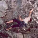
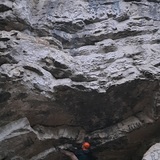
The crag is mostly overhanging. The limestone is mostly compact, but sometimes a quite brittle. Thus, beware of falling rock.

The climbing is very athletic, on mostly good holds. Bolting is on glue-in bolts. Height is about 15m

The crag has a Southern orientation and dries quickly. This is a perfect winter spot. In summer climbing is possible too, thanks to the trees who give shade.

🇫🇷
Le massif est géré par l'Union Belge de Spéléologie. C'est la commune de Durbuy qui en est le propriétaire.
Le rocher est plutôt déversant sur un calcaire parfois compact, parfois délité. Attention aux chutes de pierres.

Escalade donc très athlétique en général sur bonnes prises. Equipement sur broches. Hauteur de +/- 15m.

Le rocher est orienté plein sud et sèche très vite. On peut y grimper en hiver et en plein été aussi vu les arbres qui donnent de l'ombre.

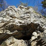
Le site se caractérise par son porche dénommé "Le Trou Diga".

History

🇬🇧
Discovered by Jean-Claude VITTOZ in 1987. JC and his friends opened 3 lines here.
Later, in 1997, Patrick LANNERS (author) bolted new routes in the overhanging sections 💪

🇫🇷
Le site d'escalade a été découvert par Jean-Claude VITTOZ en 1987. Il y ouvre 3 voies avec des amis.
Plus tard, en 1997, Patrick LANNERS équipe de nouvelles voies dans la partie déversante. 💪

⛔️Roc à l'Aisne ⛔️

Climbing is completely prohibited!

⛔️ Climbing here is not allowed. ⛔️
Climbing has been tolerated here for decades, but no longer is. Please respect this closure to protect nature and for a potential future regularisation of the crag. Wandering in the forest of the trails is not allowed either. Please stay on the trails.
The topos are only available for historic reference.

🇫🇷ci-desous
🇬🇧
The area is free to access, but is part of the Natura 2000 network. So be extra kind to nature.

The crag is located in the Province of Luxembourg, municipality of Durbuy, the valley of the Aisne, near Bomal.

🚗 Arrival by car:
From the main crossroad in Bomal, head direction "Aywaille" and turn right after about 300m towards "Izier". Pass the small church of Bomal and the « château ».
Drive another 150m and take a right on an ascending road.
Drive about 100m more meters and park alongside the road between chalet nr 4 and nr 6, near some big rocks.

🚶‍♂️Approach on foot
The trail starts on the right side of the road and takes you to the crag in 5min (see cragmap)

🇫🇷
Acces Libre, mais en Natura 2000. Donc ne pas detruire la nature.

Province de Luxembourg - Commune de Durbuy – Vallée de L’Aisne – Bomal

🚗 Arrivée par voiture
Du carrefour principal de Bomal, prenez la direction d’Aywaille et tournez à droite après +/-
300 mètres en direction d’Izier. Passez devant la petite église de Bomal et le « château ».
Roulez 150 mètres et prendre à droite une rue qui monte.
Roulez encore une centaine de mètres et se parquer le long de la route entre le chalet portant
le n° 4 et celui portant le n°6 au niveau des grosses pierres.

🚶‍♂️Approche
Le bon sentier d’accès part sur la
droite de la route. 5 minutes de marche pour atteindre Roc à l’Aisne. (voir "map")