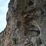

Along with nearby Camarasa, Sant Llorenç de Montgai is one of Lleida’s oldest climbing areas. Sectors such as the twin caves of Disblia and the smooth lower walls of Paret de l’Os once boasted the most difficult climbs in the region, and while this may no longer be true, the hardest of these bouldery ‘old school’ routes — either diabolically fingery or strength-sappingly powerful (and often both!) are still considered extremely tough challenges for their grades and are rarely climbed. By contrast, most of the sport climbs equipped in the last decade, and especially those established on the gently overhanging conglomerate walls of sectors Xinxetes and Mordor, feature long, sustained pitches where staMinutesa is key, and these routes have become justifiably popular, both with local and visiting climbers. As a further enticement, the higher cliffs of Sant Llorenç host a number of very enjoyable, fully bolted, middle-grade 3 and 4 pitch routes, of which a selection has been included here.
The rock is a mixture of rough, red limestone with excellent frictional properties, and bands of Conglomerate, not always a hundred percent solid but generally sound enough on our selected routes. That said, holds can and do break, and on some of the most recently equipped sectors wearing a helmet is strongly advised — if not for actually climbing then certainly for belaying.
The majority of sectors have a southerly orientation and are sheltered from cold northerly winds by the high walls of Mont-Roig just to the north, factors making winter the optimum season for climbing here. Conditions in spring and autumn may also be favourable. Summers are generally extremely hot, though at this time of year the deep, west-facing caves of sector Disblia remain shaded until mid afternoon, and evening ascents of the multi-pitch routes on the more easterly aspects of El Cilindre are also a viable proposition.
Note: fog can be a problem here in December and early January!
🧗♂️🧗♂️🧗♂️Sectors🧗♂️🧗♂️🧗♂️
🧗♂️La Formiguera🧗♂️
Although a few short, hard routes do exist here, this sector is best known for its multi-pitch lower grade climbing and is very popular at weekends and during holidays, especially with local climbers. The rock is conglomerate and mostly of good quality. Note: our selection only lists routes equipped with bolts.
🚶♂️Approximately 400m northeast of the village of Sant Llorenç de Montgai there is a spacious lay-by on the reservoir side of the road: park either here, or in an even more spacious area on the opposite side of the road at the entrance to a narrow valley — El Barranquet del Mas del Cinto (P1). From here follow a footpath up the (usually dry) streambed of the narrow valley. Approximately 250m from the road turn left and follow a path across the streambed (there is a metal ‘Ferrata’ sign glued to a rock here). Continue following this path as it climbs steeply up to the railway line near the entrance to a tunnel. For routes on the left-hand and central sections of the wall, cross the line with great care and continue along the well-marked trail running below the wall. The routes are reached by scrambling up a series of off-shot paths (15 minutes). For routes on the right-hand side of the wall, instead of crossing the railway line follow a well-marked path rightwards to the base of the routes (15 minutes). Orientation: south. Note 1: the first five routes on the wall lay approximately 200m down and to the left of the main sector and the approach involves some scrambling (25 minutes from P1). Note 2: the majority of routes can be descended by rappel, but for those wishing to walk back down to the parking area here is the description: from the top of the cliff follow well-marked tracks rightwards (east) to reach the El Barranquet del Mas del Cinto footpath, which is followed south (right) back to the road (20 minutes).
🧗♂️El Balcó de Sant Llorenç🧗♂️
This recently equipped sector predominantly features very steep climbing and some of the harder lines still await a red-point ascent. Its southeasterly orientation provides welcome afternoon shade during warm weather.
🚶♂️Approximately 400m northeast of the village of Sant Llorenç de Montgai there is a spacious lay-by on the reservoir side of the road: park either here, or in an even more spacious area on the opposite side of the road at the entrance to a narrow valley — El Barranquet del Mas del Cinto (P1). From here follow a footpath up the (usually dry) streambed of the narrow valley. At the first junction of paths, where the metal ‘Ferrata’ sign is located, continue up the main path in the streambed (going left here would take you towards sector La Formiguera. For routes on the left-hand side of the sector: approximately 100m after the metal ‘Ferrata’ sign, a vague trail cuts off to the left. Follow this diagonally up and leftwards to reach a short fixed rope leading to the base of the first 4 routes, which all share a common start (10 minutes). The start of the next 4 routes is an exposed ledge, situated a few metres down and to the right. For routes on the central and right-hand sections of the sector, continue up the Barranc del Mas del Cinto footpath until 30m before reaching a narrow tunnel that allows the stream to pass beneath the railway line, then turn left onto a vague trail heading up through the bushes, which leads to the right-hand-side of the sector (10 minutes). The final routes on this part of the sector (actually the first routes reached on the approach) start from ‘terra firma’, but heading further leftwards to the starts of the other climbs requires traversing using an in-situ rope: this is very exposed and climbers should use a harness and quick-draws to protect themselves. The bolts securing the fixed rope also serve as hanging belay anchors for some routes. Note: the route 'Espolón Sísmico' starts from a lower level than all the other climbs and is reached by rappelling off one of the anchors on the in-situ rope traverse.
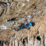
🧗♂️Sector Disblia🧗♂️
The twin caves of sector Disblia are justifiably renowned and offer some super-powerful routes on excellent rock. It is also one of the few sectors in this part of Lleida where climbing is possible in the rain.
🚶♂️Approximately 400m northeast of the village of Sant Llorenç de Montgai there is a spacious lay-by on the reservoir side of the road: park either here, or in an even more spacious area on the opposite side of the road at the entrance to a narrow valley — El Barranquet del Mas del Cinto (P1). From here a steep path heads up and leftwards across the hillside, heading directly for the twin caves of the sector (10 minutes).
🧗♂️Agulla de L’Isard🧗♂️
This is the impressive tower on the hillside directly opposite the caves of sector Disblia.
🚶♂️Approximately 400m northeast of the village of Sant Llorenç de Montgai there is a spacious lay-by on the reservoir side of the road: park either here, or in an even more spacious area on the opposite side of the road at the entrance to a narrow valley — El Barranquet del Mas del Cinto (P1). From here follow a very steep path up the base of the sector (10 minutes).
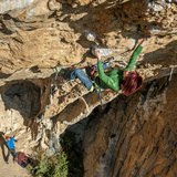
🧗♂️El Cilindre🧗♂️
This 90m high conglomerate wall offers a number of spectacular two and three pitch routes. The rock is not always perfect but the routes are well bolted. Helmets advised!
🚶♂️Approximately 400m northeast of the village of Sant Llorenç de Montgai there is a spacious lay-by on the reservoir side of the road: park either here, or in an even more spacious area on the opposite side of the road at the entrance to a narrow valley — El Barranquet del Mas del Cinto (P1). From here a well-marked footpath heads off rightwards. This is the Roca dels Bous trail (there is a large signpost where it begins) and leads towards a metal-roofed structure marking the site of Neanderthal settlement remains. El Cilindre is the first high cliff on the left (2-3 Minutes from P1). Orientation: south for routes on the front wall, east for routes further to the right. Note: rappel descents are possible for most routes but for those who wish to walk down, from the summit plateau follow a well-marked path bearing west (left) and eventually descending into El Barranquet del Mas del Cinto then turn left again (southeast) passing below the caves of sector Disblia to reach the road (15 minutes).
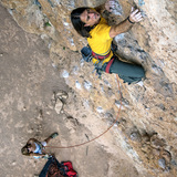
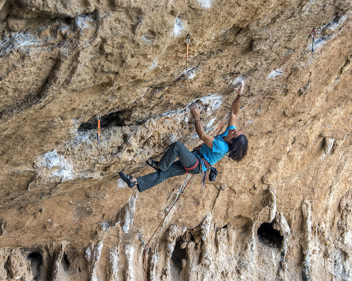
🧗♂️Xinxetes, Mordor & Clasificado “S” 🧗♂️
Although classified as three separate sectors this is in fact the same wall. The pitches are long and sustained and mostly in the 7th and 8th grades.
🚶♂️Approximately 400m northeast of the village of Sant Llorenç de Montgai there is a spacious lay-by on the reservoir side of the road: park either here, or in an even more spacious area on the opposite side of the road at the entrance to a narrow valley — El Barranquet del Mas del Cinto (P1). From here a well-marked footpath heads off rightwards. This is the Roca dels Bous trail (there is a large signpost where it begins) and leads towards a metal-roofed structure marking the site of Neanderthal settlement remains. The first wall is El Cilindre. Immediately to the right lies Xinxetes, then Mordor and finally Clasificado “S” (3-5 minutes from P1). Orientation: south, but the high, east-facing wall of El Cilindre, just to the left, begins to block the sun from the left-hand side of Xinxetes from mid-afternoon.
🧗♂️Esperó Remacha🧗♂️
A fine pinnacle offering several excellent multi-pitch routes.
🚶♂️Park on the roadside approximately 1km east of the village of Sant Llorenç de Montgai, directly below the pinnacle (P2). The walk-in is minimal (1 minute). Orientation: south. Note: rappel descents are possible for most routes but for those who wish to walk down, from the summit follow a well-marked path down the slope on the north side of the wall to reach an unsurfaced track then turn right on this and follow it back around to the main road (20 minutes).
🧗♂️Paret de l’Os🧗♂️
This roadside sector was once the focal point of hard climbing in Lleida province. The routes are mostly short and bouldery and the grades are sometimes very stiff.
🚶♂️Park on the roadside approximately 1km east of the village of Sant Llorenç de Montgai, directly below the sector (P2). The walk-in is minimal (1 minute). Orientation: south.
🧗♂️Kurtika🧗♂️
An overhanging sector featuring some spectacular routes.
🚶♂️Park in a spacious lay-by next to the Pont d’Escalera road-bridge (P3). Walk 20m along the road (towards Camarasa) then scramble up a short steep bank and through the window portal of a ruined dwelling, which is actually built into the base of the cliff. The first routes are situated immediately above the dwelling (1 minutes). The routes on the upper part of the sector are reached by continuing uphill, passing the first walls of a second dwelling on its left-hand side before re-entering the building again (3 Minutes). Orientation: east — shade from early afternoon.
🧗♂️Font del Gat🧗♂️
This small sector has easy access and its east-facing orientation makes it useful for afternoon climbing in hot weather.
🚶♂️Park in a small lay-by approximately 600m southeast of the Pont d’Escalera road-bridge (P4). Cross the road then follow a vague trail, first up and rightwards and then back left, to reach the base of the sector (3 minutes). Orientation: east.
🧗♂️Sector Trasparet🧗♂️
A sector comprising of two parts. The left-hand side of the wall offers pleasant climbing between IV+ and 6a, while further right the routes are much harder and very bouldery in style.
🚶♂️Park in a small lay-by approximately 600m southeast of the Pont d’Escalera road-bridge (P4). Cross the road then follow a vague trail, first up and rightwards and then back left, to reach the base of sector Trasparet From the left-hand side of that sector continue leftwards along a well-marked path, passing two fixed chains (aiding progress on steeper sections) to reach the base of the sector (5 minutes from P5). Orientation: east.